Scientists have discovered a huge tectonic boundary under Africa, running from Mozambique to Tanzania.
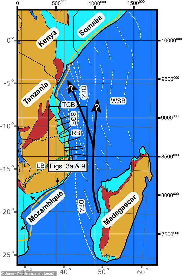
The ancient fault line, dubbed the Rovuma Transform Margin, extends over 310 miles (500km) and forms the boundary between the continent and the ocean.
Researchers say the existence of this previously unknown boundary will change how the Earth’s continents shift over millions of years.
Eventually, these forces will tear Africa in two, forming new continents and a new ocean.
Africa is already splitting down the middle along a continent–spanning fault line called the East Africa Rift System – cracking into the Nubian and Somali plates.
Co–author Dr Jordan Phethean, from the University of Derby, explained that the Rovuma Transform Margin is helping to guide these plates apart.
Speaking to the Daily Mail, he explained: ‘These faults can act like railroad tracks controlling the future direction the tectonic plate moves in.
‘It may also mean plates can rotate one way more easily than another, as there is less tectonic resistance for the plate to turn in one direction – away from the fault – than the other.’
Scientists have discovered a huge ‘fossil’ fault line extending over 310 miles (500 km), which might have been where Madagascar broke away from Tanzania
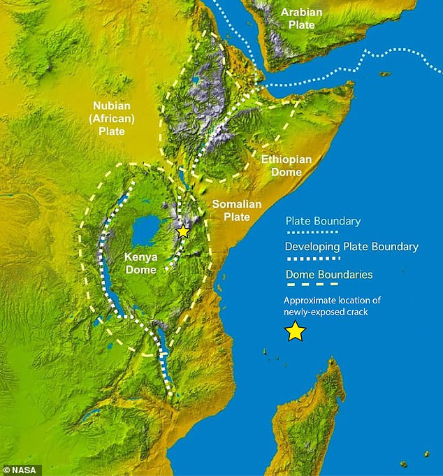
Africa is already splitting into two along the East Africa Rift System (pictured), but this newly discovered plate boundary is helping to guide the continent apart like a tectonic ‘railroad track’
The Ruvoma Transform Margin isn’t an active fault line like California’s San Andreas Fault, but a ‘fossil fault’ leftover from where two tectonic plates ripped apart.
Scientists believe that the fault line formed during the Jurassic period as the Earth’s massive supercontinents broke up in an event called the Gondwana dispersal.
However, over time, sediment carried to the sea by the Rovuma River, which forms the border between Tanzania and Mozambique, started to cover the fault.
Eventually, so much sediment was deposited that it changed the shape of Africa’s coastline, burying the Ruvoma Transform Margin beneath the surface.
Since the 1980s, scientists have fiercely debated whether or not there could be a hidden fault line running along the coast of East Africa.
But it is only thanks to the latest cutting–edge technology that geologists were able to finally put this argument to bed.
A team of scientists used gravity measurements from satellites and a technique called seismic reflection to peer beneath the surface.
Dr Phethean explains that this works like a ‘giant ultrasound scan’ of the Earth, measuring how sound waves pass through the ground to look for disturbances in the crust.
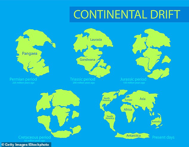
Scientists think the fault, dubbed the Rovuma Transform Margin, formed during the Jurassic period as the continent of Gondwana split into Africa and South America
What they found was a rapid transition between the continent and the ocean, with the crust becoming up to 18 miles (29km) thinner over a distance of just 10 miles (17km).
The researchers believe this is the ‘giant scar’ left behind by Africa’s dramatic transformation tens of millions of years ago.
While it might be quiet today, in Earth’s ancient history, the fault would have been an extremely active region of seismic activity.
‘Earthquakes from this 500 km long prehistoric fault line would have certainly trembled the ground beneath where dinosaurs roamed for more than 50 million years,’ says Dr Phethean.
The researchers believe that the Ruvoma Transform Margin played a key role in tearing the island of Madagascar away from its original spot in the Tanzania Coastal Basin.
‘The shape of Africa around Tanzania and Mozambique was very much dictated by the Rovuma Transform Margin around 100 million years ago,’ says Dr Phethean.
And in the next few million years, the fossil fault will help to guide the Nubian and Somali plates as they break apart along the East African Rift System.
In the very distant future, the researchers think that the fault might be activated again when tectonic stresses change.
Join the discussion
Fascinating science – or nothing we’ll ever live to see?
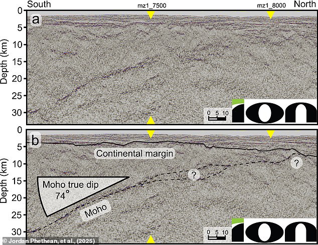
Scientists discovered the fault by using seismic reflection data (pictured), which works like a giant ultrasound scan of the Earth
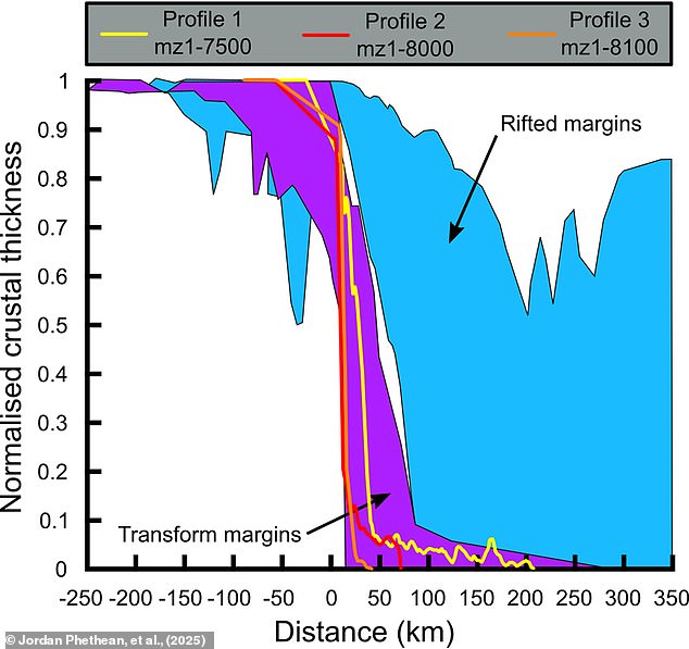
They found a rapid transition between the continent and the ocean, with the crust becoming up to 18 miles thinner over a distance of just 10 miles
This activation will help to shape the movement of the continents, as the UK drifts down towards the equator and the current continent of Antarctica makes its way towards the North Pole.
Dr Phethean says: ‘Our findings show that long–offset transform faults may be important in dictating plate motions, as opposed to only resulting from plate motions.
‘The Rovuma Transform Margin may be reactivated as continents begin to move back together – once again becoming an active fault with earthquakes and facilitating the motion of tectonic plates.
‘Eventually, we will likely have another supercontinent like Pangea!’