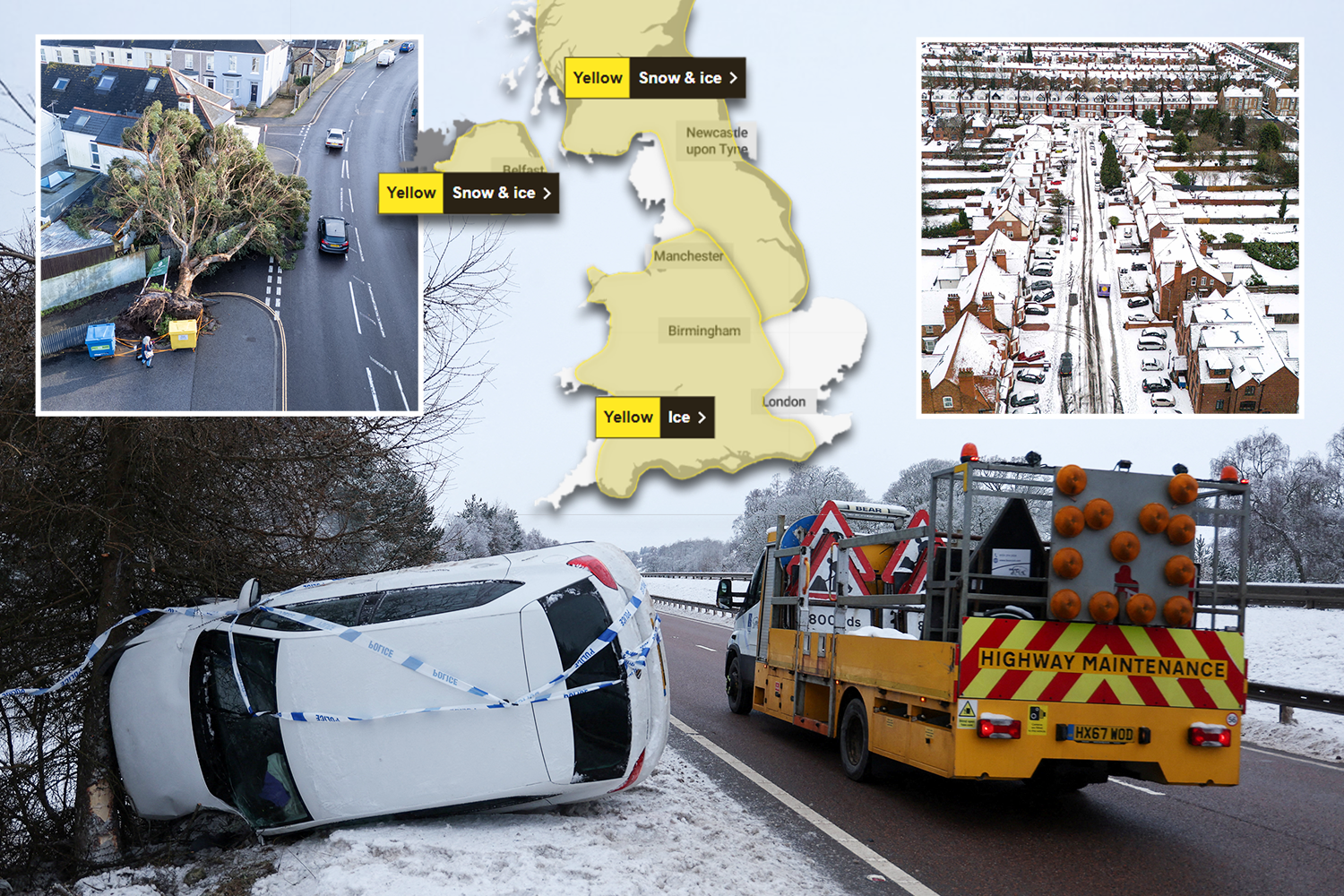
URGENT weather warnings for snow and ice have been issued across nearly the entire country, as Storm Goretti continues to batter the UK.
Yellow Met Office warnings continue until Sunday, and there are also four flood alerts and 108 flood warnings in force.
Today is the third day since Storm Goretti first hit the UK with its gale-force winds.
The south west coast has been battered by fierce gales and torrential rain, while parts of the Midlands, Wales, Scotland and the North were hit by snow.
Brits are already dealing with the dire effects of the storm, with fallen trees crushing houses and cars, and road vehicles facing treacherous conditions.
Many train and airport services have been disrupted, while Warwick racing was abandoned today due to the havoc caused by the wild weather conditions.
About 28,000 properties were still left completely without power in the South West this morning, according to the National Grid’s website.
There were also close to 1,700 in the West Midlands and about 150 in the East Midlands, while all power has been restored in Wales.
Downing Street said support was being offered to homes struggling without power.
The Met Office has huge swathes of the country under yellow warnings for snow and ice today, including Northern Ireland, Scotland and much of the North of England.
Baltic showers are expected to drift in from the freezing North Sea, with likely snowfall above 100m elevation.
It also warned ice would be a “widespread hazard” in these areas.
There is also a yellow weather warning for ice in force in Wales, the West Midlands, and much of the South West.
It warned the icy conditions could become dangerous due to “partially thawed snow refreezing, accompanied by freezing fog and a few wintry showers”.
“Freezing fog patches” are also likely, making the threat of dangerous icy conditions even worse.
Forecasters warned that the combination of melting snow and rain will increase the flood risk for some in the coming days.
The four flood alerts, where flooding is expected, are in place across the south and south west, including the River Ouse and River Beult.
The 108 flood warnings, where flooding is possible, are in place on rivers across the country.
Dan Stroud, Met Office meteorologist, said the weather over the weekend will remain “unsettled and cold”.
He said: “Wintry showers will continue to affect some coastal areas on Saturday, although these will increasingly become confined to northern and eastern parts as the day progresses.
“Elsewhere, after a cold and frosty start, it should be a mostly dry day with variable amounts of cloud. It will be a widely cold day, with frost lingering across parts of the country.”
Forecasters recorded 27cm of snow at Altnaharra in Scotland, and 15cm of snow at Lake Vyrnwy in Powys.
The Met Office said a low of -12.3C was recorded in Braemar yesterday.
In Cornwall – where effects of the storm have been worst felt – 100mph wind brought down power lines and trees.
Gusts of 99mph were recorded at St Mary’s Airport on the Isles of Scilly and 90mph in Culdrose, Cornwall.
The county also recorded the highest rainfall total, with 61.8mm at Colliford Dam.
Travel chaos was sparked in the West Midlands where drivers were stuck in five miles of traffic.
Meanwhile, both Birmingham Airport and West Midlands Airport were forced to close after the storm blanketed runways in snow.
Looking ahead to Sunday, Stroud predicted the day “will start dry in the east, but cloud and rain already present in the west will move steadily eastwards”.
A yellow weather warning for snow and ice will remain in force across Scotland and the north of England tomorrow due to “a spell of snow” which “will lead to some disruption”.
He added: “The rain will fall as snow inland across the north Midlands and areas further north.
“However, temperatures will rise through the day, meaning the snow will become increasingly confined to higher ground by the afternoon.
“It will be windy for all, with coastal gales and the potential for severe gales in the north west later in the day.
“The unsettled but increasingly milder theme continues into next week, with persistent rain at times in northern and western areas, along with strong to gale force winds.
“However, it will feel much milder than recently, with temperatures returning to near-normal values.”