Families still mopping up after the weekend’s Storm Ingrid were warned to expect more chaos today as torrential rain, snow and strong winds are set to batter Britain.
Some 120 areas have been put on flood watch as Storm Chandra barrels in.
The Met Office issued ten yellow or amber warnings for up to 3.1in of rain, 8in of snow and 80mph gusts.
The 35-hour storm began hitting South-West England from yesterday afternoon, before spreading to the rest of the UK.
Forecasters said some communities could be ‘cut off’ by flooded roads, following Storm Ingrid when part of Teignmouth’s Grand Pier washed away and police launched a search for a missing kayaker in Devon.
A series of Atlantic weather systems is driving wet and windy conditions across Britain, with snow likely on higher ground in the Pennines and Scottish mountains. But the strongest winds will be in the South-West and Wales, where 80mph gusts could hit Pembrokeshire and the Isles of Scilly.
The UK Health Security Agency activated cold-health alerts for northern England until Friday amid a ‘greater risk to life of vulnerable people’.
RAC’s Nick Mullender warned: ‘Flooding is highly likely, making many roads dangerous. Our message to drivers is simple: do not drive through standing water unless you are completely certain the water is shallow enough and it’s safe to do so.
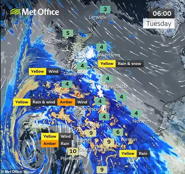
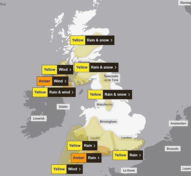
The Met Office has issued ten yellow or amber warnings in southwest England, Scotland, Wales and Northern Ireland
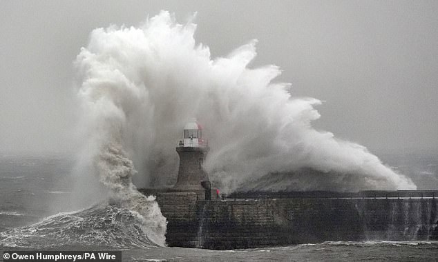
Waves crash against South Shields lighthouse on the North East coast during Storm Ingrid last week
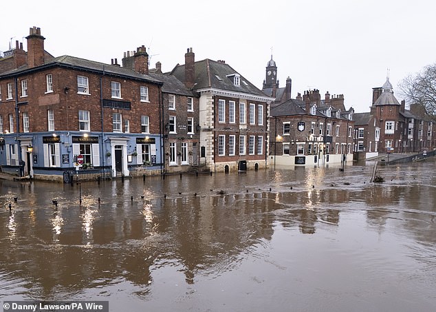
More than 100 flood alerts have been put in place across the UK. Pictured: Flooding in York after the River Ouse burst its banks on Sunday
‘In these conditions, drivers need to slow down and stay alert. Wet roads can double stopping distances, so taking a cautious, steady approach and allowing extra time to react is essential.
‘And if your vehicle already has known faults, now is not the time to take risks. Avoid unnecessary journeys and get issues fixed promptly by a trusted mobile mechanic or local garage.’
And the Met Office said there could be ‘large waves’ in some coastal areas covered by the warnings, with potential for ‘debris being blown around’ and ’tiles coming off roofs’.
According to chief forecaster Steve Willington: ‘Unsettled conditions will continue through the week, with a combination of rain, brisk winds and some further hill snow, particularly in northern areas where colder air remains in place.’
Chris Wilding, flood duty manager at the Environment Agency, said: ‘Due to the arrival of Storm Chandra, significant surface water flooding impacts are probable today and tomorrow in the south west of England, and tomorrow there is a significant risk of river flooding impacts too.
‘Elsewhere, it is possible that there will be impacts across parts of the north, south and south east of England tomorrow.
‘Environment Agency teams are out on the ground, taking action to reduce the impact of flooding and support those communities affected. We urge people not to drive though flood water – it is often deeper than it looks and just 30cm of flowing water is enough to float your car.’
An amber weather warning is in place on the east coast of Northern Ireland until 9pm today, with an additional yellow rain and wind warning for the whole of Northern Ireland for all of Tuesday.
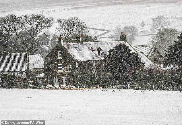
In Scotland yellow warnings for snow have been put in place as some higher regions could see up to 8in fall
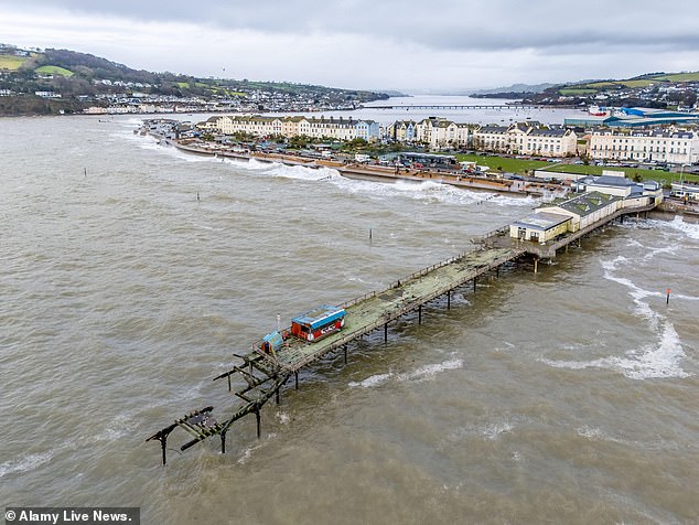
Warnings for wind and rain are in place for Devon, where Teignmouth Pier has already seen huge damage caused by storms
An amber warning for rain is in place for south Devon, much of Dorset, southern Somerset and south-east Cornwall until 9am on Tuesday.
Less severe yellow warnings are in place for a more extensive area of southern England, as well as parts of northern England and Scotland.
A yellow warning for wind covers Cornwall, southwestern Wales and parts of northern Devon from 5am to 4pm on Tuesday, with an additional yellow wind warning in force for southwestern Scotland for 5am to midnight on Tuesday.
Yellow warnings for rain and snow have also been issued for the Pennines and southwest Scotland from midnight to 5pm on Tuesday where up to 8in of snow could fall at higher elevations.
Yellow warnings for rain and snow are also in place across much of central Scotland until midnight on Tuesday.
A yellow warning for rain is in place from midnight until midday on Tuesday for much of southeast England, and for south west England and south and central Wales until 10am on Tuesday.
During Storm Ingrid over the weekend, Devon and Cornwall Police responded to reports of a kayaker getting into difficulty on the River Exe in Tiverton on Saturday.
The kayak was recovered but the man, who is in his 40s, remains missing.

Floodwater in York city centre yesterday after the River Ouse burst its banks on Sunday
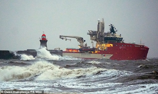
The Dogger Bank wind farm vessel passes the damaged South Shields sea wall on Sunday
A sea wall protecting the railway line at nearby Dawlish partially collapsed and train services were suspended between Exeter St Davids and Plymouth on Saturday.
Part of the historic Teignmouth Grand Pier washed away in the storm – while in York, the River Ouse burst its banks over the weekend.
In South Shields, a sea wall on the South Pier suffered a partial collapse during Storm Ingrid – having been previously damaged by severe weather in 2023 when Storm Babet ripped off the pier’s lighthouse.
Now Storm Chandra is set to bring more chaos to towns and cities across the country.
In the southwest of England, members of the public have been warned to expect cancellations to train and bus services and flooding in some areas which could leave some communities cut off.
Drivers have been urged to avoid travelling by road during potentially dangerous conditions.
A Met Office spokesperson said: ‘If you must travel, ensure you watch for possible danger and drive cautiously.’
In Dorset and Devon, where an Amber warning for rain is in place, this could also lead to landslides at the coast.
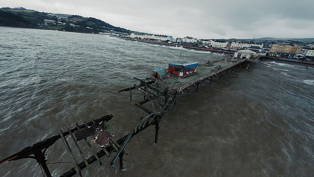
Aerial images showed the destruction caused to Teignmouth Grand Pier caused by Storm Ingrid

Devon and Cornwall Police were called to reports of a missing kayaker over the weekend
Met Office Chief Forecaster, Paul Gundersen, said: ‘Storm Chandra will bring a range of hazards to the UK.
‘Initially strong winds will impact the Isles of Scilly, western Cornwall and southwest Wales which are still vulnerable after Storm Goretti, gusts of 70 to 80mph are possible here.
‘Heavy rain is an additional hazard as it falls on saturated ground in Dorset and southern parts of Devon, Somerset and Cornwall.
‘As Chandra interacts with colder air further north snow becomes a hazard, with 10-20cm of snow possibly accumulating over higher ground in the Pennines, southern Scotland and the Highlands.
‘With a complex spell of weather, its important people stay up to date with the forecast and any warnings in your area.’
The Met Office has advised residents of areas at risk of flooding to prepare a kit which could save families from loss or damage.
It suggested having a kit containing insurance documents and a list of contact numbers, a torch with spare batteries, a first aid kit and any prescription medicines, waterproof clothes along with bottled water and snacks.
On Wednesday, the weather will continue to be unsettled with more spells of wet and windy weather but should also bring some dry spells.
Storm Chandra is the next storm to be named by the western Europe storm naming group list shared between the UK, Ireland and Netherlands.