The best and worst suburbs to live in England – according to a tranche of statistics covering everything from house prices to crime and even broadband speeds – can today be named.
Topping the Daily Mail’s league table of almost 7,000 neighbourhoods is Withdean Woods in Brighton, where Edwardian homes on tree-lined streets and sequestered woodland trails are commonplace.
It scores 85.2 out of 100 when judged across our eight metrics, which also include transport links, deprivation, air quality, income and easy access to green spaces.
Brighton, as a whole, fell within a desirable ‘wedge’ which swept through the south east, encompassing swathes of Oxfordshire, Buckinghamshire, Hampshire, Surrey and Sussex.
Lincoln Green and St James in Leeds ranks dead last, however, with a score of just 7.7 out of 100.
All of our metrics were combined to create a score for all of England’s 6,856 MSOAs (middle-layer super output areas) – neighbourhoods home to around 10,000 people.
You can see how your area compares with the map below.
Reacting to the analysis, Lucian Cook, head of residential research at Savills told the Daily Mail: ‘Brighton is an affluent city and is better connected to London better than some other areas so it attracts more affluent people.
‘It has also become increasingly cool in the past 25 years so you can imagine the pull that has.’
He added: ‘You tend to find these things become self-fulfilling: affluent people are attracted to an area because of the fundamentals, so it gets a reputation as an aspirational area.
‘It becomes a bit of a virtuous circle leading to high-value hotspots.’
Crime
Most suburbs that fell within the ‘wedge’ had a crime rate of below 40 reports per 1,000 population in the year to July, putting them inside the top 20% safest neighbourhoods in the country.
This could include reports of assaults, drug dealing, theft and shoplifting.
Despite the overall trend within the wedge, there were a few crime hotspots inside Reading, Portsmouth, Brighton and Gatwick Airport.
Outside of the wedge, crime was most rife in London, Birmingham, central Liverpool and Leeds, according to our analysis of official police statistics for the 12 months to July.
House prices
Despite coming top when all metrics are combined, house prices have not performed as well within the wedge, or most of the south east and London in general.
While house prices have risen in the past six years in most neighborhoods, the total increase has hovered around 10%, which is less than inflation, meaning many houses will have lost value in real terms.
Neighbourhoods with the biggest increase in house prices were concentrated in the north, with Old Trafford, Manchester, seeing the largest rises in value.
There, prices leapt 162% – from an average sale price of £114,000 in the year to July 2019 to around £300,000 in July just gone, according to our analysis of Land Registry data.
Daily Mail analysis also shows average prices have dipped by at least 10% since pre-Covid in nearly 140 different suburbs across England and Wales.
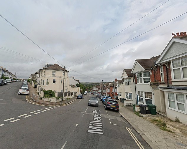
The Withdean Woods neighbourhood in Brighton (pictured) topped our league table of the best areas in England
Income
Nearly every single MSOA within the wedge has an average disposable household income (after taxes and housing costs) of more than £35,000 a year, well within the top 20% of al neighbourhoods in the country.
Posh central London neighbourhoods such as Kensington top the tables, where the equivalent figure exceeds £60,000 a year.
Other parts of the country pocketing big pay packets include the Cotswolds, Bristol and Cheshire, according to ONS data on incomes for 2020 – the most up-to-date available.
Eastern areas have some of the poorest incomes in the country, however, with a belt of low income neighbourhoods running up the east coast from Norfolk to Newcastle-upon-Tyne.
The joint lowest levels of income in the country are in the Shearbridge & University neighbourhood of Bradford, which includes the city’s university campus, and St Matthews & Highfields North in Leicester, where disposable income after housing costs is just £14,400 a year.
Deprivation
The wedge has among the lowest levels of deprivation in the country, according to data from the 2021 Census. Almost every MSOA inside the wedge is within the top 10% of least deprived neighbourhoods in the country.
Sparkbrook North, in Birmingham, is technically the most deprived area in England, with 79% of households facing deprivation.
Birmingham, as a wider city, features several more times in the most deprived areas, including in Saltley East and Nechells neighbourhoods.
A household is considered deprived in education if no adults have at least GCSE-level qualifications, in employment if any non-student adult is unemployed or economically inactive, in health if a household member has poor health, or in housing if the property is either overcrowded or has no central heating.
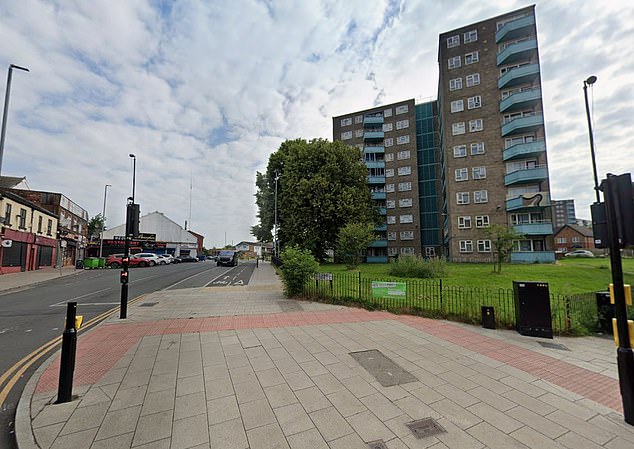
Lincoln Green and St James in Leeds (pictured) ranked last on our league table
Rail connectivity
Nationwide, very few neighbourhoods are within a 15 minute walk of a train station – except inner-city suburbs.
Although blessed with rail networks galore that allow commuters to hop in and out of London easily, the wedge doesn’t rank overwhelmingly well in this metric.
Train stations in the area, although well connected to the capital, aren’t always next door to housing estates.
This lack of access to public transport, collected in a report from the ONS in 2024, has affected the area’s overall score.
However, the wider region does have access to several major motorways, including the M3, M4, M25, M23 and M27.
Access to green space
On its doorstep are the roaming hills of the South Downs and the Chilterns, and the picturesque villages of the Cotswolds are only a short drive away for some.
So it’s rather unsurprising that MSOAs within the wedge typically have some of the best access to green spaces, according to a comprehensive 2020 analysis by the ONS.
That said, MSOAs in the wedge don’t typically rank as well as the majority of London, where nearly every neighbourhood has hundreds of acres of parks within 1km.
Residents of Windsor Town and Eton – on the northern edge of the wedge – have the most access to green space in the country of more than 7,000 acres. Nearby public green spaces include Home Park and the Royal Windsor Great Park, which is 5,000 acres itself.
Residents of Featherstone West, Coven and Shareshill in Staffordshire have the worst access, however, with just 32 square meters of parks and public fields available within 1km.
Broadband
Internet connectivity meets basic speeds in the vast majority of neighbourhoods in the south east wedge, according to a 2024 analysis of Ofcom data by the House of Commons Library.
In three-quarters of all neighbourhoods in country, fewer than 5% of residents have broadband speeds below the ‘universal service obligation’ of 10mbps downloads.
Below those speeds, much of the modern internet is unusable.
The best connected area is Didcot South East in South Oxfordshire, which has become somewhat of a hub for the tech sector.
US firm CloudHQ is in the process of planning and building a £1.9bn data centre campus in the town at the disused Didcot A coal power station.
The worst connected part of the country is Cathedral and Kelham in Sheffield City Centre.
Air quality
The best air quality in the country is concentrated around the Lake District, where average daily exposure to PM2.5 is around 4 micrograms per cubic meter of air.
The figures, from 2023, are from an Institute for Fiscal Studies (IFS) study of Environment Agency data.
PM2.5 are tiny particles of pollution mainly emitted by burning diesel and petrol.
It is considered the most dangerous type of air pollution because it can penetrate deep into the lungs and worsen respiratory diseases. PM2.5 exposure contributes to tens of thousands of deaths each year.
The World Health Organization says a ‘safe’ level is under 5 micrograms per cubic meter of air a day.
The worst air quality is, unsurprisingly, in London where exposure can be double safe levels of 10 in the city centre.
However, much of the south east Wedge, has significantly better air quality, ranging from around five to six.